
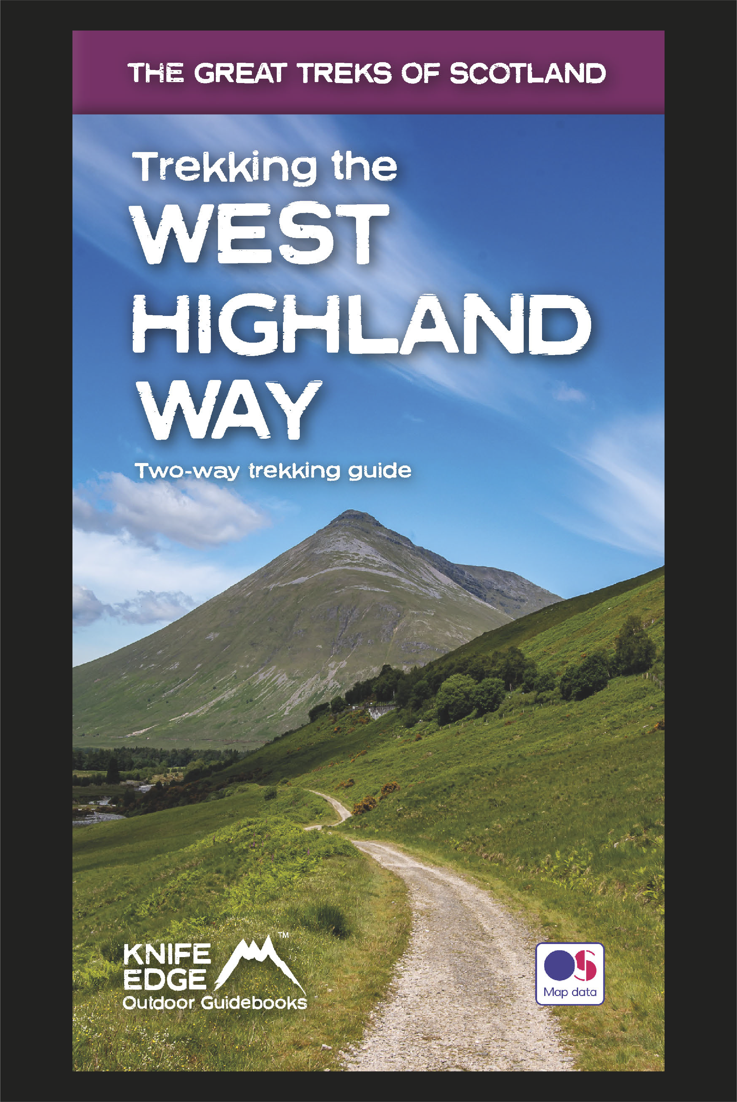


Trekking the West Highland Way: Two-way guide
Available Now!
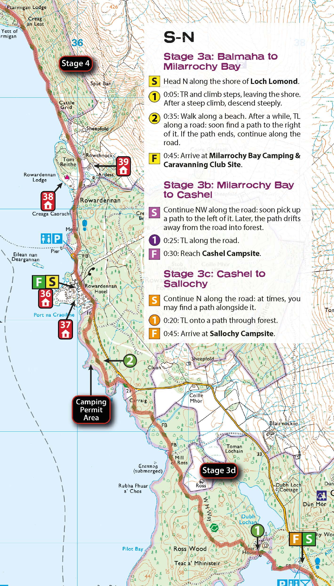
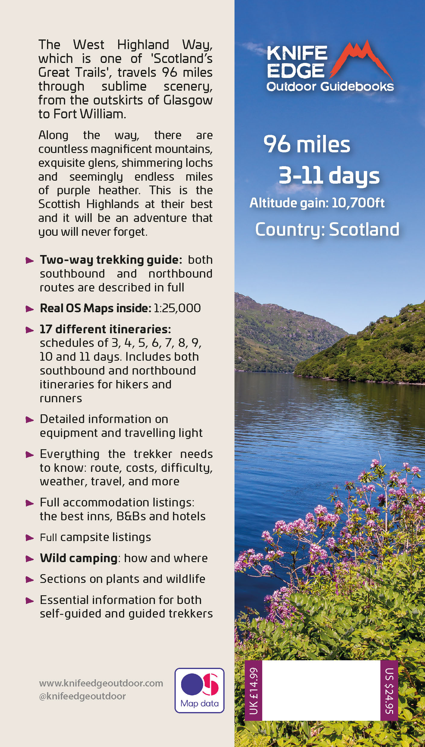
The definitive two-way guide to the West Highland Way: both northbound and southbound routes are described in full.
Real Maps: Full Ordnance Survey Explorer mapping inside (1:25,000)
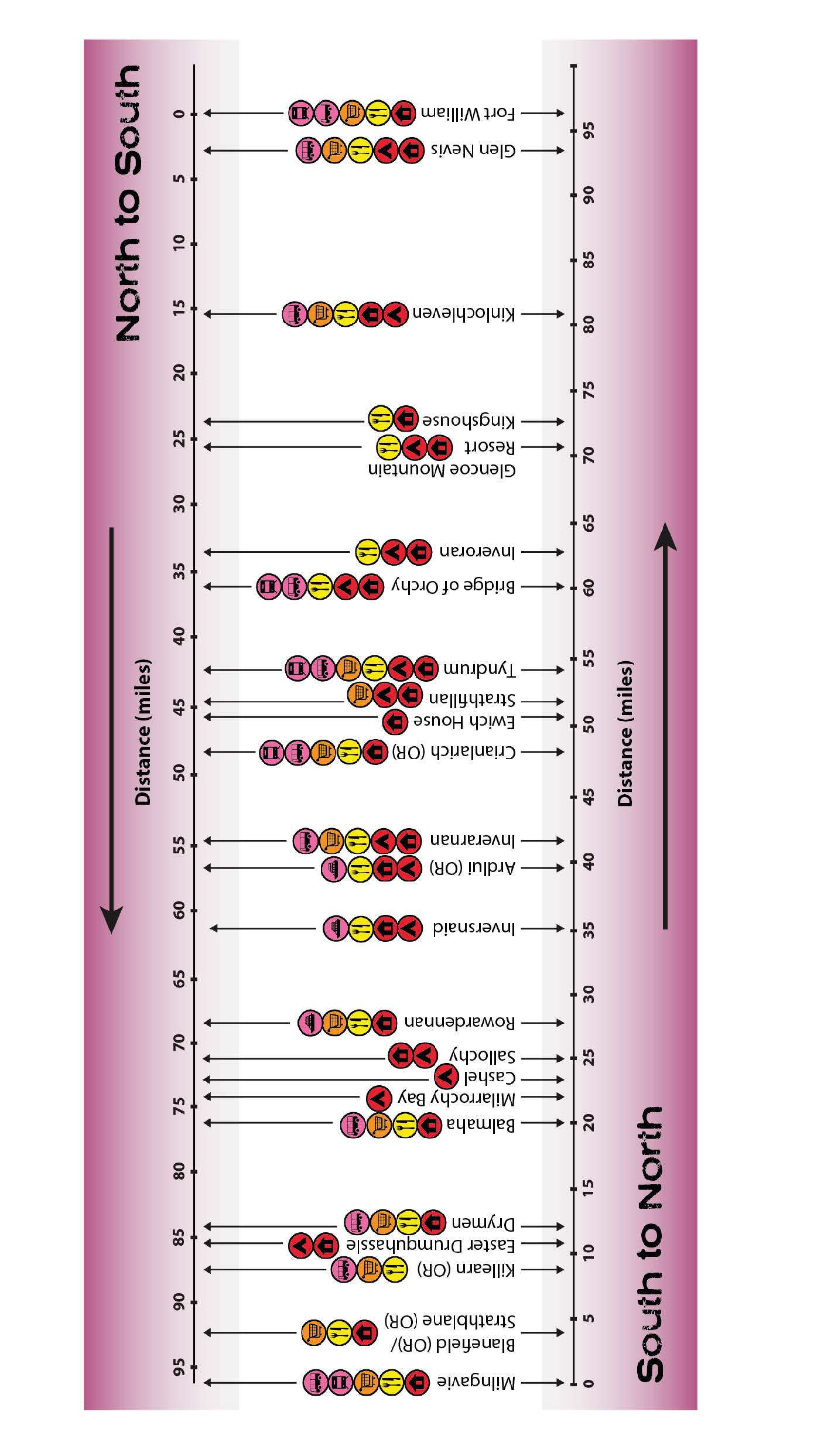
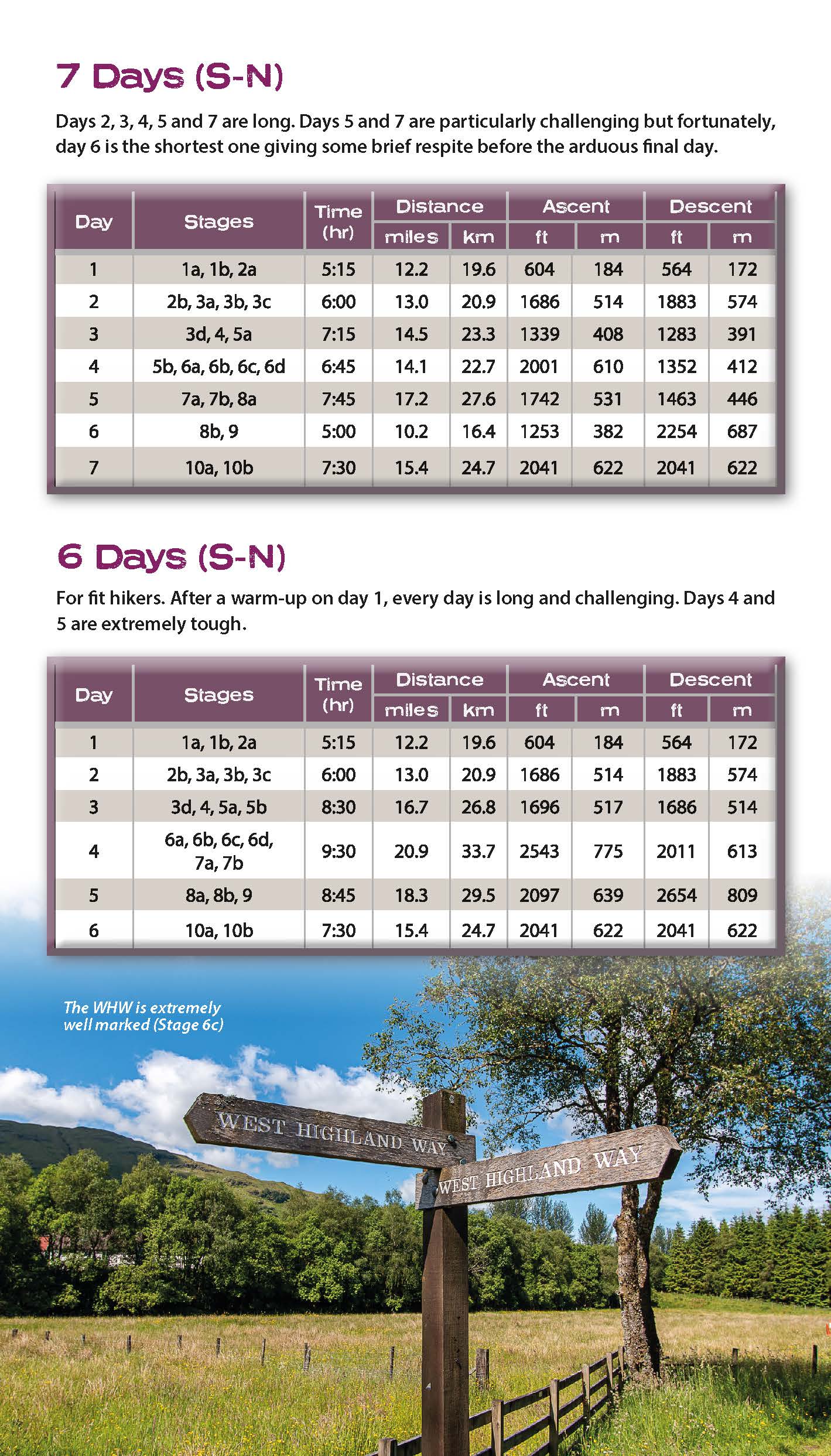
17 different itineraries: schedules of 3, 4, 5, 6, 7, 8, 9, 10 and 11 days for hikers and runners. Includes both southbound and northbound itineraries. Difficult calculations of time, distance and altitude gain are done for you.
Also includes:
- Detailed information on equipment and travelling light
- Everything the trekker needs to know: route, costs, difficulty, weather, travel, and more
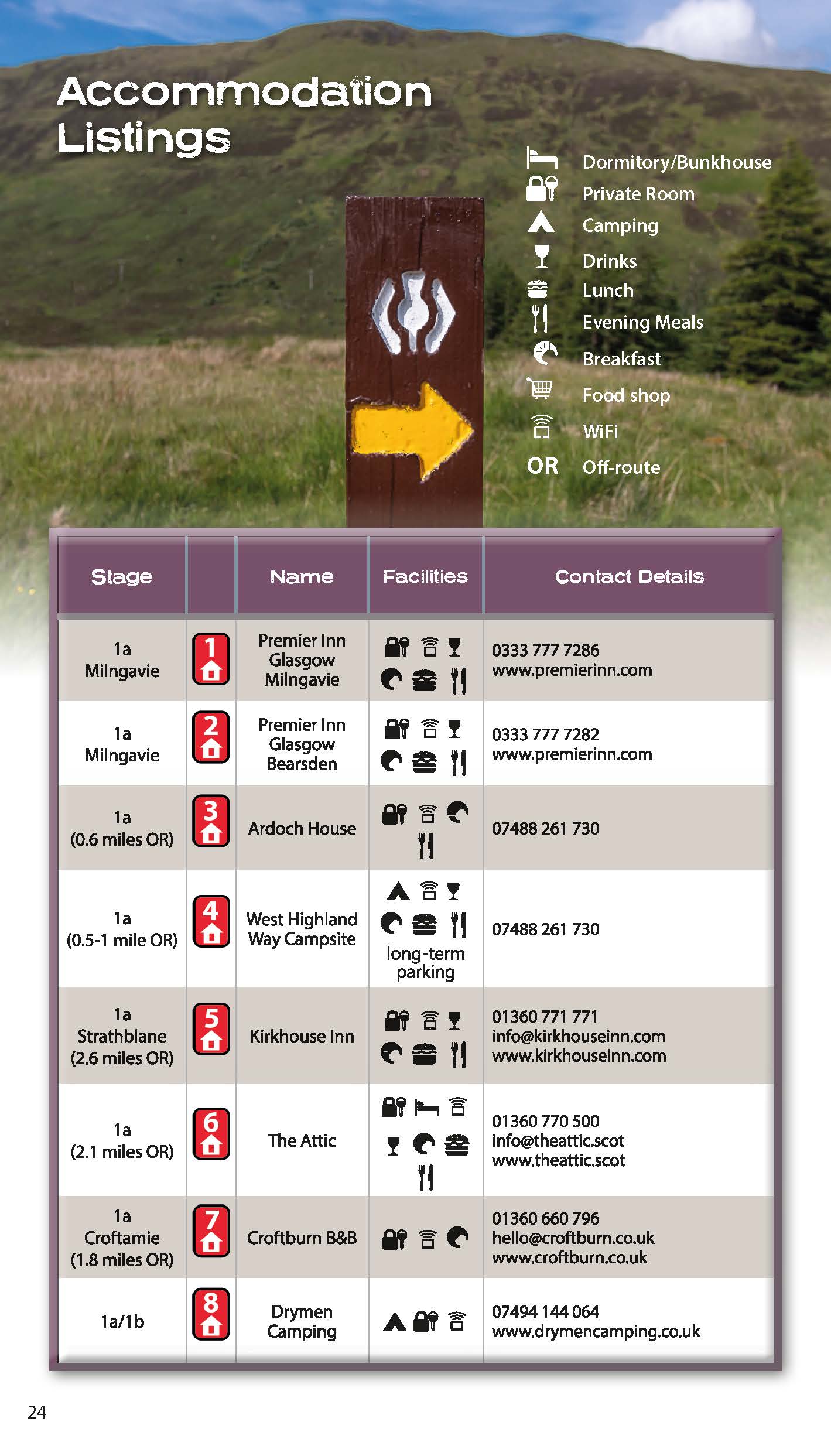
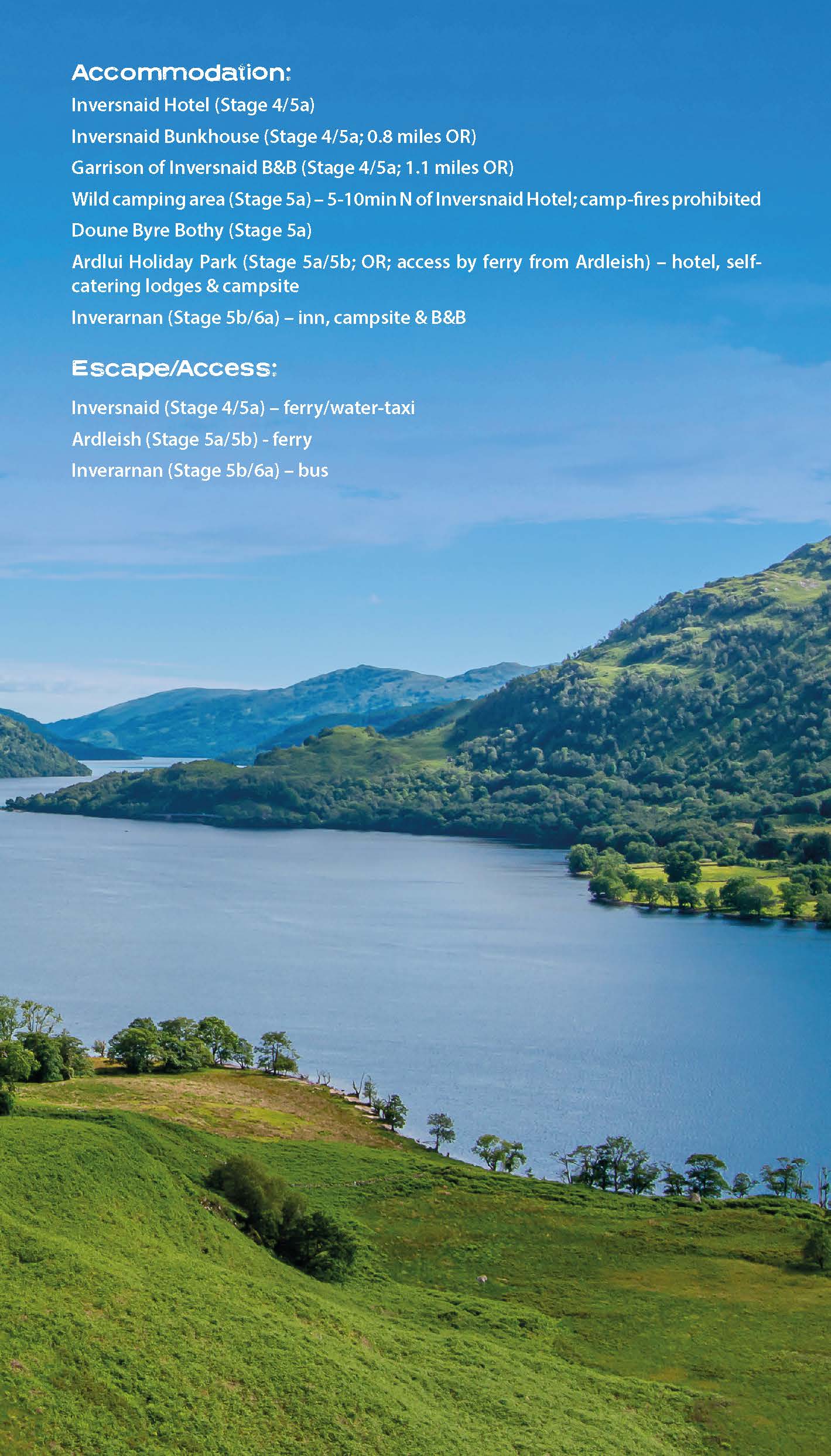
- Full accommodation listings: the best inns, B&Bs and hotels
- Detailed section on camping
- Essential info for both self-guided and guided trekkers
- Information on geology, history, plants and wildlife
- Numbered waypoints linking the Real Maps to our clear descriptions
Trekking the Hadrian’s Wall Path (2024 Updated Version)
Available now!
Real OS maps 1:25,000
The definitive two-way guide to the Hadrian’s Wall Path: both eastbound and westbound routes are described in full.
14 different itineraries: schedules of 3, 4, 5, 6, 7, 8 and 9 days for walkers and runners. Includes both northbound and southbound itineraries. Difficult calculations of time, distance and altitude gain are done for you.
Also includes:
- Extraordinary detail on the history and construction of Hadrian’s Wall
- Section on the unmissable forts of Hadrian’s Wall
- Detailed information on equipment and travelling light
- Everything the trekker needs to know: route, costs, difficulty, weather, travel, and more
- Full accommodation listings: the best inns, B&Bs and hotels
- Information for both self-guided and guided trekkers
- Numbered waypoints linking the Real Maps to our clear descriptions
Hadrian’s Wall was one of the Romans’ most ambitious structures. When completed, it ran for 73 miles between the west and east coasts of Northern England. It crossed the crags and hills of some of Britain’s wildest and most beautiful terrain.
The Hadrian’s Wall path is one of England’s official ‘National Trails’. It leads you on an unforgettable journey of discovery along the route of the Wall. Discover the incredible surviving sections of the Wall and its forts, milecastles and turrets.
Trekking the South Downs Way
The definitive two-way guide to the South Downs Way: both westbound and eastbound routes are described in full.
Real Maps: Full Ordnance Survey Explorer mapping inside (1:25,000)
18 different itineraries: schedules of 4, 5, 6, 7, 8, 9, 10, 11 and 12 days for walkers and runners. Includes both westbound and eastbound itineraries. Difficult calculations of time, distance and altitude gain are done for you.
Also includes:
- Detailed information on equipment and travelling light
- Everything the trekker needs to know: route, costs, difficulty, weather, travel, and more
- Full accommodation listings: the best inns, B&Bs and hotels
- Detailed section on camping
- Essential info for both self-guided and guided trekkers
- Information on geology, history, plants and wildlife
- Numbered waypoints linking the Real Maps to our clear descriptions
The South Downs Way leads you on an unforgettable journey of discovery through the magnificent chalk hills of Sussex and Hampshire. It travels the length of the South Downs National Park across wonderful hills and meadows bedecked with wild-flowers, through endless fields of shimmering golden corn and along the edge of the epic white cliffs of the Seven Sisters and Beachy Head. It is one of England’s official ‘National Trails’ and is an unforgettable experience
Trekking the Cotswold Way
Available Now!
The definitive two-way guide to the Cotswold Way: both southbound and northbound routes are described in full.
Real Maps: Full Ordnance Survey mapping inside (1:25,000). All accommodation is numbered and marked on the maps.
18 different itineraries: schedules of 4, 5, 6, 7, 8, 9, 10, 11 and 12 days for hikers and runners. Includes both southbound and northbound itineraries. Difficult calculations of time, distance and altitude gain/loss are done for you.
Also includes:
- Detailed information on equipment and travelling light
- Everything the trekker needs to know: route, costs, difficulty, weather, travel, and more
- Full accommodation listings: the best inns, B&Bs and hotels
- Detailed section on camping
- What to see in the City of Bath
- Essential info for both self-guided and guided trekkers
- Information on history, plants and wildlife
- Numbered waypoints linking the Real Maps to our clear descriptions
Trekking the Coast to Coast Path
Available Now!
The definitive two-way guide to the Coast to Coast Path: both eastbound and westbound routes are described in full.
Real Maps: Full Ordnance Survey mapping inside (1:25,000). All accommodation is numbered and marked on the maps.
19 different itineraries: schedules of 11, 12, 13, 14, 15, 16, 17, 18 and 19 days for hikers and runners. Includes both eastbound and westbound itineraries. Difficult calculations of time, distance and altitude gain/loss are done for you.
Also includes:
- Detailed information on equipment and travelling light
- Full accommodation listings: the best pubs, B&Bs and hotels
- Detailed section on camping, including wild camping
- Everything the trekker needs to know: route, costs, difficulty, weather, travel, and more
- Essential info for both self-guided and guided trekkers
- Information on plants and wildlife
- Numbered waypoints linking the Real Maps to our clear descriptions
Trekking the Cleveland Way: Two-way guidebook with OS 1:25k maps: 20 different itineraries
Available Now!
The definitive two-way guide to the Cleveland Way, one of England’s epic National Trails: both eastbound and westbound routes are described in full.
Real Maps: Full Ordnance Survey mapping inside (1:25,000). All accommodation is numbered and marked on the maps.
20 different itineraries: schedules of 5, 6, 7, 8, 9, 10 and 11 days for hikers and runners. Includes both eastbound and westbound itineraries. Difficult calculations of time, distance and altitude gain/loss are done for you.
Also includes:
- Detailed information on equipment and travelling lightFull accommodation listings: the best pubs, B&Bs and hotels
- Detailed section on camping, including wild camping
- Everything the trekker needs to know: route, costs, difficulty, weather, travel, and more
- Essential info for both self-guided and guided trekkers
- Information on plants and wildlife
- Numbered waypoints linking the Real Maps to our clear descriptions
Northern Ireland: the Unmissable Walks
The definitive guidebook for walking in Northern Ireland: 36 epic walks hand-picked by a County Down local.
The only guidebook for Northern Ireland with real OSNI maps inside: this makes navigation easy.
The Causeway Coast, the Glens of Antrim, the Mourne Mountains, the Sperrins and much more.
Also includes:
- New walks in the Mournes which were not included in our previous Mourne Mountain book: including the Mournes Grand Traverse, our newly designed 55km challenge circuit which has been divided into two stages.
- Game of Thrones film locations
- List of Irish place names
- Numbered waypoints linking maps to text
Tour du Mont Blanc (2022 updated version)
Complete guidebook for planning and trekking the Tour du Mont Blanc, the world's most famous trek
Real maps for each stage: 1:25,000. No need to carry a separate map!
Unique Itinerary Planner: plan a bespoke itinerary to match your ability and vacation schedule. All difficult calculations of time, distance and altitude gain are done for you
Everything the trekker needs to know: route descriptions, costs, budget, difficulty, weather, how to get there, and more
Full accommodation listings: spectacularly situated mountain huts, villages and hamlets
Full section on camping: a complete list of camping locations
10 exciting variants to the main route!
Information for both self-guided and guided trekkers
Trekking the Dolomites AV1 (2024 updated version)
Fully Updated for 2024!
The only guidebook exclusively for the AV1.
Real maps inside (Tabacco 1:25,000): the finest maps available for the Dolomites.
Everything you need to know to plan and walk Italy's most popular long distance route.
Also includes:
Numbered waypoints linking maps to text
Unique Itinerary Planner: plan a bespoke itinerary to match your ability and vacation schedule. All difficult calculations of time, distance and altitude gain are done for you
7 Proposed Itineraries of between 6 and 11 days
Everything the trekker needs to know to plan the route: route descriptions, costs, budget, difficulty, weather, how to get there, and more
Full accommodation listings: spectacularly situated mountain huts
Section on Camping
Exciting variants to the main route
Information for both self-guided and guided trekkers
Edge to edge colour: the most modern and beautiful guidebooks
Trekking the Corsica GR20
Available now!
The only two-way guide to the GR20: both northbound and southbound routes are described in full.
Real IGN Maps included (1:25,000): no need to carry separate maps.
15 different itineraries: schedules of 9, 10, 11, 12, 13, 14, 15 and 16 days. Includes both northbound and southbound itineraries. Difficult calculations of time, distance and altitude gain are done for you.
Also includes:
- Detailed information on equipment and travelling light
- Detailed information on getting to/from all trail-heads
- Everything the trekker needs to know: route, costs, difficulty, weather, travel, and more
- Full accommodation listings: spectacularly situated mountain huts and campsites
- Information for both self-guided and guided trekkers
- Numbered waypoints linking the Real Maps to our clear descriptions
- Information on Wildlife and Plants
Trekking the Mallorca GR221
Available Now!
The definitive two-way guide to the Mallorca GR221 (the Drystone Way): both northbound and southbound routes are described in full.
Real Maps: Full mapping inside (1:25,000) by Editorial Alpina. All accommodation is numbered and marked on the maps.
12 different itineraries: schedules of 7, 8, 9, 10 and 11 days for hikers and runners. Includes both northbound and southbound itineraries. Difficult calculations of time, distance and altitude gain/loss are done for you.
Also includes:
- Detailed information on equipment and travelling light
- Full accommodation listings: the best hotels and refugis
- Everything the trekker needs to know: route, costs, difficulty, weather, travel, and more
- Public Transport map and information
- Essential info for both self-guided and guided trekkers
- Information on the drystone structures along the route
- Information on plants and wildlife
- History of drystone structures along the route
- Numbered waypoints linking the Real Maps to our clear descriptions
Trekking Iceland's Laugavegur Trail (& Fimmvörðuháls Trail)
Available Now!
The definitive two-way guide to Iceland's Laugavegur Trail (& Fimmvörðuháls Trail): both southbound and northbound routes are described in full.
Real Maps: full mapping inside (1:40,000), made specifically for the treks by Knife Edge Outdoor Guidebooks. All accommodation/campsites are numbered and marked on the maps.
14 different itineraries: schedules of 2, 3, 4, 5, 6 and 7 days for hikers and runners. Includes both southbound and northbound itineraries. Difficult calculations of time, distance and altitude gain/loss are done for you.
Also includes:
- Detailed information on equipment and travelling light
- Full accommodation/campsite listings
- Everything the trekker needs to know: route, costs, difficulty, weather and more
- Travel to the trail-head
- Essential info for both self-guided and guided trekkers
- Information on the volcanic sights along the route
- Information on plants and wildlife
- History of Iceland
- Numbered waypoints linking the Real Maps to our clear descriptions
Trekking Map: Iceland's Laugavegur Trail (& Fimmvörðuháls Trail)
Available Now!
Waterproof sheet map for Iceland's Laugavegur Trail (& Fimmvörðuháls Trail): 1:40,000. Includes free GPX downloads for the trails.
The definitive map to Iceland’s two best trails: larger scale and more detail than any other map. Made specifically for the treks by Knife Edge Outdoor Guidebooks.
- Waterproof
- Free GPX downloads
- Tough
- Lightweight
- All huts/campsites are marked
- Information on distances, times and altitude gain/loss between huts/campsites
- Hot springs and fumaroles are marked
The Laugavegur Trail is one of the world's most beautiful and aspirational treks. It leads you into the heart of Iceland’s unique ice-capped, volcanic terrain. Experience spectacular and unusual landscapes, the likes of which you will not find anywhere else on the planet. Impressive volcanic peaks are a constant companion and steam gushes from the ground. This is Iceland at its best and it will be an adventure that you will never forget
